Introduction
GPS trackers, with their ability to pinpoint, it has been deeply integrated into multiple scenarios such as personal safety (such as child protection, elderly care) , vehicle management (fleet scheduling, anti-theft tracking) , pet anti-lost (outdoor pet activity positioning) and asset tracking (logistics containers, valuable equipment monitoring) . Many users in the purchase or use, will focus on a core issue: GPS Tracker effective range of how much? In this paper, the technical principle (including multi-satellite system) , key influencing factors (supplementary environment and equipment details) , coverage characteristics of different types of equipment and practical application optimization strategies will be discussed, the scope of the GPS Tracker is comprehensively analyzed to provide users with a more practical reference.
![]()
First, the range of GPS tracker principle
The“Effective range” of GPS tracker is not a single index, but is determined by the satellite positioning range and the information transmission range, and the two can work together to achieve complete tracking function.
1. Satellite positioning range: NOT JUST GPS, global system coverage
The Tracker first calculates a location by receiving a satellite signal, where the“GPS” can actually be extended to a global navigation satellite system (GNSS) , these include GPS in the United States, Beidou in China, GLONASS in Russia and Galileo in the European Union. The satellites of these systems are globally networked and could theoretically cover any part of the Earth’s surface, including remote areas such as the polar regions and oceans.
In outdoor open environment (such as grassland, suburban Highway) , the tracker can receive more than 3 satellite signals without obstruction, and complete positioning (receiving 4 or more satellites can improve the accuracy to 1-5 meters) , at this time, the satellite positioning link has no geographical range limit.
2. Information transmission range: the key to“Remote location”
Satellite positioning only allows the tracker itself to obtain location data, which needs to be transmitted via communications technology to the user’s mobile phone APP or cloud server, a step that is the core constraint to“Effective tracking range”. Common transmission methods and range characteristics are:
Cellular: 2G/3G/4G/5G and low power wan (NB-IoT, Lorawan) . 4G/5G coverage is the same as the carrier’s base stations, with over 95% coverage in cities, counties and major highways. Nb-iot/Lorawan is designed for the Internet of things, with wider coverage (1-10 km radius for a single base station) and lower power consumption, for long-term tracking of static assets such as warehoused goods.
WI-FI: relies on router signal, usually 10-50 meters radius, mainly for indoor auxiliary location (such as shopping malls, Home) , Tracker and Wi-Fi hotspot in the same network.
Radio/RF/Bluetooth: short-range transmission technology, Bluetooth (e.g. Bluetooth 5.0) covers 50-100 meters and is suitable for close-range communication (e.g. pets automatically switch their location when they enter home Wi-Fi range) Radios (such as the UHF band) cover tens of metres to several kilometres and require base stations for reception (such as asset tracking in the park) .
Satellite communications: for extreme scenarios without cellular networks (such as deserts and oceans) , some professional trackers support satellite communications and can be transmitted globally, but the cost is high and the power consumption is large, most of them are used for exploration and ocean-going ship tracking.
To sum up, the“Effective range” of GPS trackers is a combination of the“Unlimited potential” of satellite positioning and the“Practical limitations” of communication transmission, which are often the core factors affecting the user’s perceived range.
Key factors affecting the range of GPS Tracker
In addition to the underlying communications technology, there are four core factors that will further affect the tracking range in practice that users need to focus on:
1. Communication Technology Selection: matching the scene is the key
Cellular Networks (4G/5g/NB-IoT) : suitable for remote tracking scenarios (such as cross-city transportation, elderly people travel) , but remote mountainous areas (such as deep mountains, unmanned areas) may not have a signal;
Wi-fi + Bluetooth: only suitable for indoor or short distance outdoor (such as pet tracking in the community) , out of range can not transfer data;
Satellite Communication: only recommend extreme no signal scene, daily use cost-effective.
2. Environmental interference: the“Stealth killer” of signal attenuation
Geographical occlusion: High-rise city (signal reflection by buildings, occlusion) , tunnels, underground garages, dense forests (leaves block satellite signals) will lead to increased satellite positioning bias, or even unable to locate;
Bad Weather: heavy rain, snow, fog will weaken the satellite signal strength, may lead to positioning accuracy from 1-5 meters to 10-20 meters;
Electromagnetic interference (EMI) : electromagnetic radiation from industrial sites (such as substations and workshops) and high-voltage lines can interfere with the Tracker’s communications module, causing interruptions or delays in data transmission.
3. Device hardware performance: power and antenna“Hard power”
Antenna type: external antennas (e.g. , roof antennas for car trackers) provide 30% to 50% more reception than built-in antennas (e.g. , tiny antennas for children’s bracelets) , making it easier to maintain communications in areas with weak signals (e.g. , on the edge of the suburbs)
Transmit Power: high-power modules, such as industrial trackers, can travel farther, but consume more power; low-power devices, such as small pet collars, have low transmit power and are vulnerable to long-distance transmission.
4. Battery and power: battery life decisions“Continuous tracking capability”
High-power Communications (such as 4G real-time positioning) can drain power quickly, and if the battery capacity is low (such as a children’s bracelet for 1-3 Days) , it may stop working during long-distance tracking due to power failure Some devices (such as vehicle tracker) can be connected to the vehicle power supply, no need to worry about endurance, can achieve 24-hour continuous tracking.
Range comparison of different types of GPS trackers
![]()
The tracking requirements of different scenarios are quite different, and the corresponding devices also have significant differences in communication methods and actual ranges, as shown in the following table:
| Type of device | Core means of communication | Scope of validity of the theory | Scope of practical use and limits of scenarios |
| Personal trackers (child/elderly bracelets) | Cellular (4G/NB-IoT) + Bluetooth | Global (cellular) + 50-100 meters (Bluetooth) | Good coverage in cities and suburbs; no cellular signal in remote mountainous areas (such as mountains and plateaus) ; bluetooth is only used for“Lost alert” at close range (e.g. , when a child is 10 meters away from the parent) . |
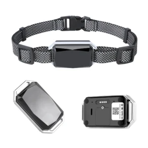
| Pet trackers (dog and cat collars) | Cellular + Bluetooth + GPS/Beidou | Global (cellular) + 50-150 meters (Bluetooth) | Outdoor areas (parks, suburbs) can be pinpointed, while indoor areas (pets in closets) may rely on Bluetooth or WI-FI for location because of weak satellite signals Large dogs should be monitored for battery life (usually 2-7 days) . |
| Vehicle Tracker (private car/fleet) | Cellular (4G/5g) + in-car power | Global (cellular) | Good coverage of urban roads, expressways and rural roads; satellite positioning failure in underground garages and tunnels, some high-end equipment can be combined with“Inertial navigation”(temporary calculation of position by speed and direction) ; Support 24-hour continuous tracking. |
| Asset Tracker (logistics boxes/equipment) | Nb-iot/Lorawan + Bluetooth | 1-10 km (NB-IoT/Lorawan) + 50m (Bluetooth) | Suitable for warehousing, campus, cross-city Logistics: indoor warehousing with Bluetooth“Inventory positioning”, cross-city transport with NB-IoT location; static assets (such as idle equipment) can upload data at low frequency (1 time/hour) , battery life 6-12 months. |
| Industrial/logistics tracker (container/truck) | Cellular (4G) + satellite (optional) | Global (cellular + satellite) | Conventional transport with 4G, ocean, desert and other non-signal area can switch satellite communications; support“Temperature and humidity + location” dual tracking, suitable for cold chain logistics, dangerous goods transport. |
| Outdoor Adventure Tracker (mountaineering/sailing) | Satellite Communications + GPS/Beidou | Global (satellite) | It can be used in extreme scenarios (such as Snow Mountain and ocean) without any ground signal. It requires regular recharge of satellite communication fees, and the cost of single positioning data transmission is high. |
Practical methods for improving the effective range of GPS trackers
If you want to make the tracker in the actual use of more extensive coverage, positioning more stable, can be optimized from the following five aspects:
1. Choose communications on demand: avoid“Mismatch” scenarios
4G/5G cellular networks for long-distance tracking (such as moving vehicles across a city)
Static assets (such as warehouse goods) NB-IoT/Lorawan (low power, wide coverage) ;
Extreme no-signal scenarios (e.g. expeditions) with satellite-based equipment.
2. Give preference to Multi-mode Positioning
Multi-mode positioning (GPS + beidou + GLONASS + Wi-Fi + Bluetooth + inertial navigation) can cope with complex environments:
Satellite positioning is used outdoors, Wi-Fi/Bluetooth is used indoors, and inertial navigation is used in tunnels to realize“Seamless switching” and avoid positioning interruption.
3. Optimize equipment placement
Vehicle Tracker: installed on the roof, the front windshield below (no shelter) , to avoid sticking metal film (will shield the satellite signal) ;
Personal/pet trackers: worn on the outside of the body (e.g. wrists, collars) to avoid being obscured by clothing or backpacks;
Asset Tracker: fixed to the top or side of the equipment, away from metal parts (e. g. the corner of a container) .
4. Choose sensitive hardware and battery life
Antenna: preferred external antenna type (such as external GPS antenna of vehicle tracker) , weak signal area performance is better;
Battery life: Personal/pet trackers for high-capacity batteries (7 days or more) , asset trackers for low-power models (NB-IoT devices) .
5. Regular maintenance and support optimization
Equipment Maintenance: regular cleaning antenna (to avoid dust shielding) , check the SIM card (cellular equipment) is due or signal normal;
Operator selection: cellular equipment selection base station coverage rate of operators (such as city selection three operators, remote areas selection support“Roaming” Internet of Things Card) ;
Software settings: according to the needs of the adjustment of positioning frequency (such as daily tracking set 1/5 minutes, emergency set 1/10 seconds) , balance accuracy and endurance.
Summary
The“Range” of a GPS tracker is essentially a combination of“Satellite positioning capability” and“Data transmission capability”:
Satellite positioning end: relying on global satellite navigation system (GPS/Beidou, etc.) , theoretically no geographical restrictions, outdoor open area can achieve precise positioning;
Information Transmission Terminal: restricted by communication technology (cellular, Wi-Fi, satellite, etc.) , it is the core of determining whether the location can be obtained remotely, and the matching transmission mode should be selected according to the scene.
In practical use, open urban areas and outdoor environments are the“Best scenarios” for the tracker, while indoor, underground, remote mountain areas and other areas with weak signals, it is necessary to improve the coverage effect by means of multi-mode positioning and optimization of installation location. Through reasonable selection, hardware optimization and scene adaptation, the GPS tracker can achieve stable and accurate all-weather tracking in scenarios such as personal safety, vehicle management and logistics tracking, provide reliable location guarantee for users.
For example, by equipping containers with“NB-IoT + GPS” trackers and combining them with the cloud platform, a logistics enterprise has realized the full link location monitoring from the warehouse to the end customer, real-time access to the location of cargo even in remote mountainous areas has increased transport efficiency by 20 per cent and dropped the loss rate to less than 0.1 per cent-a typical application of“Technology selection + scenario adaptation”.

